Follow the route of the Pioneers and experience the northern Australian frontier.
Day 1
From Cairns head to Mareeba where you will get the chance to sample great food, wine and coffee. Visit the Mareeba Heritage and Information Center for maps and information.
From Mareeba head west along the Chillagoe Road to Dimbulah. Along the way you will see colourful and unique tobacco barns with a strong mediterranean influence. The country side is a picaresque, undulating agricultural landscape with a variety of tree crops, smallcrops, and fodder crops.
At Dimbulah, follow the signs to Mt Mulligan and the Tyrconnell Gold Mine.
Mt Mulligan is a stark geological feature, and was once the site of a coal mine and small town. Visit the ruins of Mt Mulligan township, a town with a tragic history, and experience the wonder of a mountain sacred to the kuku djungan people.
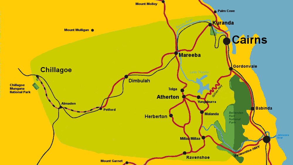
Tyrconnell Gold Mine survives as the remnant of a once thriving gold field. A working gold battery provides demonstrations of gold processing, and gold can be panned in the stream nearby. Andrew and Cate offer guided tours, and a great night-time story telling experience in the old bush cemetery.
Accommodation is available at Tyrconnell in the beautifully restored cottages or in the camping area.
Day 2
From Tyconnell head back to Dimbulah and turn right on the Chillagoe Road toward Chillagoe.
Now you are entering an outback landscape with undulating views over Emu Creek Station toward bush-clad mountains. Emu Creek Station offers camping along Emu Creek, with good fishing. Call (07) 4094 8313
At Petford, turn left toward Emuford-Irvinebank-Herberton. Petford is the remnant of an old town. The road is gravel and is not suitable for most rented conventional vehicles. It is a narrow winding but very scenic drive through the foothills of the Great Dividing range.
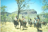
A few kilometers from Petford there is a scenic stretch of Emu Creek with a rest area beside a large prominent natural rock - tower, known locally as 'Castle Rock'. This is a special place for the people of the Mbarburrum tribe who can be found a few kilometers further on at the Mbarburrum Outstation.
At Emuford a one lane bridge crosses Emu Creek. If you turn right instead of crossing the bridge, you will find the Emuford Battery - a working condition century-old tin battery which is being progressively restored. John and Sharon Fitzgerald have a wonderful collection of old cars, trucks, and horse drawn carriages, as well as a great collection of semi - precious stones and artefacts from the local area.
From Emuford the track undulates over low ridges, following creek flats where it can all the way to Irvinebank. There are brumbies (wild horses), and a lot of wildlife along this section. Great care should be taken on this road as visibility is often poor around corners, and the road is narrow.
A lot of mines and old workings will be seen either side of the road. In the wet season (summer) the road may become flooded.
At Irvinebank you will find a peaceful mountain village with a townscape reminiscent of the turn of the 20th century. Loudoun House Museum contains fascinating artefacts, intriguing stories, and an extensive photographic collection of the regions' early development, when Loudoun House and Irvinebank were the center of a vast outback mining empire.
Irvinebank contains many historic buildings and old mines. Printed versions of the Town Tour are available from Loudoun House Museum. People who have offroad vehicles, or who enjoy bushwalking will find great side tours such as the spectacular lookout from the top of Mt Misery, sites of old townships, remote ruins, and old cemeteries.
Accommodation at Irvinebank is provided at the Irvinebank Tavern with comfortable motel - style cabins and free camping, showers, and toilets.
Day 3
From Irvinebank the road winds through a narrow valley with mine sites and tunnels viewable from the road, along with the remnants of the old 'Bridle Path' to Herberton. Over the Jumna range and about 6 kilometers from the township is the Jumna Dam on the right. This area is a good viewing area for Irvinebank's rare flora, the Acacia Purpureapetala (Purple Wattle) and Grevillea Glossanenia (Glossy Grevillea). Both flower after the summer storms. This is also the area where the Koala is making a comeback, as the forest regrowth repairs the environmental damage caused by mining.
Another 4 kilometers to Bakerville. Once the site of a small township, only a station homestead remains. In another couple of kilometers the sealed road begins and the countryside changes to Granite Boulders, some of which are spectacularly balanced. A pioneer cemetery is marked by a sign on the left at the top of the hill.
This is the site of Watsonville, another former township. Seven Hotels onced graced this peaceful spot and two stamper batteries served the myriad mines of the district. At the bottom of the Watsonville range is a windmill standing starkly in the middle of the road. On it is a touching poem titled 'A town that used to be'.
Another 10 kms through picaresque mountain views and you will come to Herberton - the first town established on the tablelands.
Disclaimer: Although we've tried to make the information on this web site as accurate as possible, we accept no responsibility for any loss, injury or inconvenience sustained by any person resulting from information published on this site. We encourage you to verify any critical information with the relevant authorities before you travel. This includes information on visa requirements, health and safety, customs, and transportation.